- Beranda
- Berita dan Politik
ARTIKEL RISET GUNUNG PADANG dimuat di New Dawn 152 (September-October 2015)
...

TS
infobenar
ARTIKEL RISET GUNUNG PADANG dimuat di New Dawn 152 (September-October 2015)
DOES A JAVA HILLTOP HIDE THE WORLD’S OLDEST PYRAMID?
Could the largest megalithic site in Southeastern Asia be over 20,000 years old? For answers, Bruce Cunningham spoke to the chief geologist at Gunung Padang...By BRUCE CUNNINGHAM --
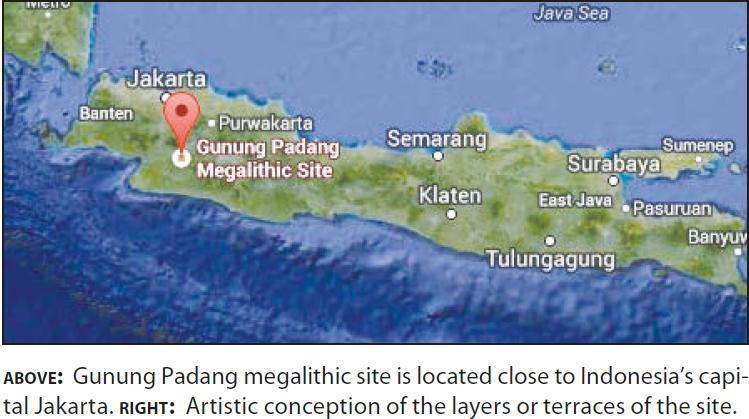
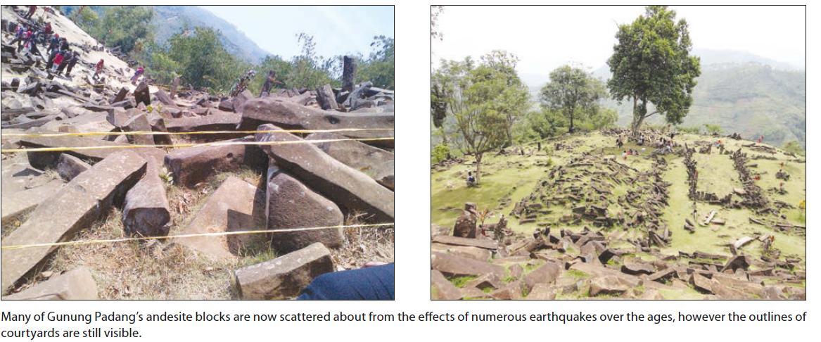
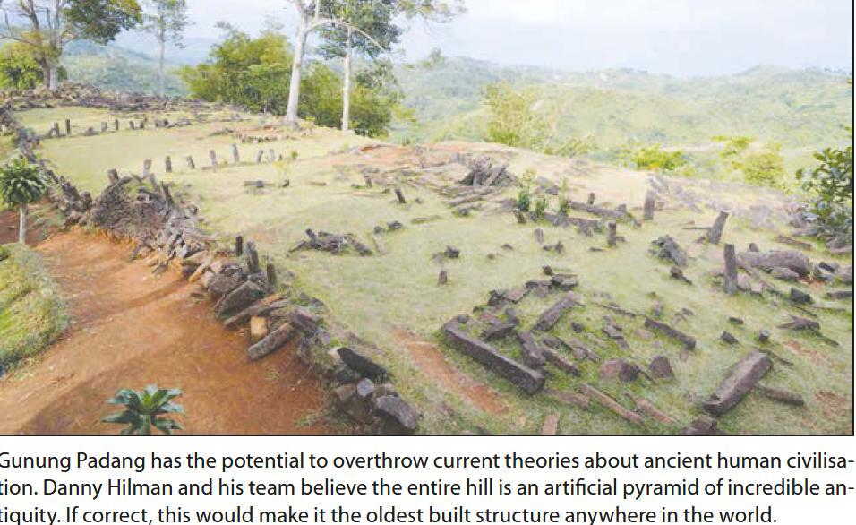
The largest megalithic site in all of Southeastern Asia may also be the oldest on Earth. At nearly three thousand feet above sea level, Gunung Padang spreads over a Java hilltop in a series of terraces bordered by retaining walls of stone. These are accessed by about four hundred successive andesite steps rising more than three hundred feet. The seventy-two-acre complex is covered with massive, rectangular stones of volcanic origin, known as magnetised ballast. They lie just outside Karyamukti village, thirty-two miles southwest of the city of Cianjur, in Indonesia’s West Java Province. Although the location was mentioned as long ago as 1914 by a Dutch report, it was virtually unknown to the outside world until as recently as three years ago.1 In 2012, an Indonesian government survey team generated international publicity by announcing that carbon radiometric probing of base structures twenty-four to thirty feet beneath the surface of the above-ground site dated to 12,500 Years Before Present, making it, if true, humankind’s oldest-known building project. Digs were brought to a halt last October when geo-radar readings indicated the entire hill on which the archaeological zone sits may itself be an ancient pyramid of enormous, if currently indeterminate proportions. So far, the re-discovery of this surprising mystery has prompted more questions than it has answered. To throw some light on those challenging enigmas, I turned to the location’s resident expert. Danny Hilman Natawidjaja is the chief geologist in charge of excavations at Gunung Padang. After training in geology at the Bandung Institute of Technology and Auckland University, he completed his doctoral degree at the California Institute of Technology. Dr. Natawidjaja is currently the Indonesian Institute of Sciences’ senior geologist at the Center for Geo-technology Research. As President of Ancient Mysteries International,2 I was particularly interested in what he could tell me, because I was in the midst of organising the first-ever tour of its kind to Gunung Padang. I began by asking him why it took so long for Gunung Padang to gain the recognition it deserves?

DR. DANNY HILMAN NATAWIDJAJA (DHN): The site has actually been known since the late 19th century, when it was deemed nothing more than a chaotic collection of simple stone structures, possibly belonging to some old cemetery. No real studies were conducted for another one hundred years. Since 1980, it gradually began dawning on Indonesian scholars that the area in question spread far beyond the single, hilltop sector they previously assigned it. But they additionally failed to explore the entire summit, and no subsurface exploration was conducted, except only a one-meter-deep test-pit. Without attempting any real dating analysis, they assumed that the place was built sometime during prehistory, perhaps even as long ago as the mid 1st Millennium BCE. That would at least have put it into the chronological context of Indonesian megalith building. From then on, possibilities for something significant began to grow.
BRUCE CUNNINGHAM (BC): What first drew you to the site?
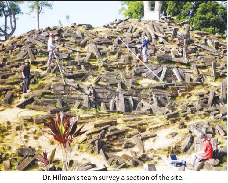
DHN: During 2011, I got especially interested in Gunung Padang after noticing that the peculiar surface morphology – based on its degree of erosion – looked much younger than the surrounding landscape. Then, in October, I began going over the archaeological zone with ground penetration radar and resistivity surveys. Results were astonishing. Geophysical images revealed a number of buried artificial structures, some of them quite large. News spread about our findings, and soon crowds of people began visiting Gunung Padang for the first time. We followed by conducting comprehensive and intensive studies using almost all geophysical methods including 2-D and 3-D resistivity, geomagnetic, and seismic tomography surveys, as well as conducting geological core drillings, together with archaeological and geological excavations. Our studies show that the site is much broader, advanced and complex than previously imagined, but most of it is subterranean and lies buried.
BC: What is the base or foundation for Gunung Padang? What is it standing on?
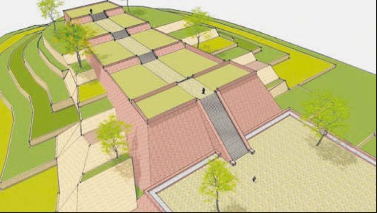
DHN: Not easy to answer because what we have here is a multi-layered construction successively built up in different stages or phases over time. The megalithic structure on the surface is underlain by soil – perhaps man-made fill, natural soils from weathering or combinations of both – covering the entire hilltop. Around the very summit construction sits on artificially filled-in soil about one to three meters thick. What amazes me, this underlain soil is buried beneath the surface of the older constructions, which I call the ‘second layer.’ Underneath it, there are still the third and fourth layers. The fourth layer, which is about fifteen meters in depth from the surface of the ground, is a natural, massive, lava, basalticandesite formation, but it was probably made by ancient construction engineers to become the core of Gunung Padang, exactly at the very centre of the hill. In other words, the second and the third layers are wrapped around the lava andesite. If we make a cross section perpendicular to Gunung Padang’s long axis, then the shape of the second, third, and fourth layers form a precise prism, or truncated pyramid, flat on top. So, in a general sense, we can say that the core foundation of Gunung Padang is a massive, volcanic lava formation.
BC: What has all this got to do with the controversial time-parameters associated with the site?
DHN: I determined the age of the construction using current radiocarbon dating methods. In principle, we date the age of carbon flakes or grains of soil that intercalated in the stone structures. Assuming that the dated carbons are bio-organic remains from biological activities from the time of construction or habitation, then the duration of carbon-14 decay since the bio-organisms died are related to certain building phases and their age.
BC: How many construction phases have you found at Gunung Padang?
DHN: We identified four layers. However, there are still some interesting structures beneath the fourth, deepest and, consequently, oldest layer, though we need further studies to investigate what they really are.
BC: Can these construction phases be individually dated?
DHN: Yes, we have carbon dates for each layer. The first or surface layer was constructed between 1000 BCE and 500 BCE, perhaps somewhat earlier. The second phase or layer was built around 5000 BCE. The third dates to before 8000 BCE, possibly between 11,000 and 24,000 BCE. We are unable to determine the age of fourth level construction because it is entirely composed of massive, basaltic rock, which contains no carbon. This deepest phase of andesite lava is Mid-Pliocene rock, which has a geological age going back millions of years ago.3
BC: When was Gunung Padang finally abandoned?
DHN: It seems there were several evacuations corresponding to each concluding construction phase. We don’t know when the uppermost or last layer was abandoned, signifying a final exodus. We should understand that Indonesia’s written history only goes back to about 400 CE, nearly one thousand years after Gunung Padang’s residents left for the last time. Some researchers, trying to envision the site within our country’s historical or even legendary context, argue that it must have been built by the monarch of Pajajaran, a Hindu kingdom that flourished in West Java from 669 CE to around 1579 CE, according to the Bujangga Manik manuscript.4 They believe that King Siliwangi was not able to finish construction, and that’s why the hill-top location looks rather messy or unfinished. These comparisons are invalid because Pajajaran was founded some eleven centuries after Gunung Padang was abandoned for the last time.
BC: Why did its residents finally leave?
DHN: We simply don’t know. Perhaps natural, catastrophic events took the lives of many native peoples and disrupted their lives in Java and elsewhere. We do know catastrophic events periodically occurred throughout geological history, and these happenings would have certainly impacted human populations, just as they do today around the world. Likewise, we don’t know why southern Turkey’s Göbekli Tepe was forsaken and buried around 7000 BCE.5 It and Gunung Padang are only two of many places of formerly high culture that were abandoned for causes unknown.
BC: What was the original purpose of Gunung Padang?
DHN: Again, we do not know. However, various, partially exposed architectural features, particularly at the first and second layers, suggest religious intentions. For example, a truncated, pyramid-shaped stone resembled an altar for animal or human sacrifices. Many local people regard Gunung Padang as a sacred place, and conduct religious activities there because they say it radiates vibrant, mystical frequencies or energies. Residents during the ancient past may have felt much the same. Returning to Göbekli Tepe again for the sake of comparison, the magnificence of such a complex alone implies something more than economic or political for original inspiration.
BC: Why did Gunung Padang’s construction engineers choose to build with basalt?
DHN: Perhaps a more appropriate question might be: Why did they build on a natural lava hill in the first place? From the landscape point of view, this lava mount is a good local landmark. It sits beautifully in the centre of a surrounding, higher, U-shaped mountain ridge facing the magnificent and active Gede-Pangrango volcano to the north. From a practical social perspective, the subterranean, tongueshaped lava body overlays a large water reservoir in a permeableaquifer layer. Water of this aquifer leaking on the north side of the hill was a vital resource. In all the past millennia, it has never gone dry, and is very good water, with neutral pH, and local people consider it a sacred spring for healing energy. Still a mystery is the source of the columnar rocks that were used to construct the second and the first phases and also some parts in the third layer. We conducted extensive geological mapping around the entire site area, but were unable to locate the origins for Gunung Padang’s chief building materials. From six core drillings at the site, we did not encounter any natural columnar-joint rock formations. Could the ancient construction engineers have obtained them from sources outside the Karyamukti area, even beyond Java?
BC: If so, they suggest a people not native to this part of Indonesia. Who do you think they may have been?
DHN: No one can say at this point because we’re still too early into our investigations. Answers may lie within underground chambers at the third and particularly fourth levels, inside the massive lava rock.
BC: How much of Gunung Padang is known, and what do you believe the full dimensions of the site might turn out to be after it has been fully brought to light?
DHN: We sank more than a dozen test-pits atop the hill, on the eastern and western slopes, penetrating two to four meters in depth, going as far down as eleven meters on the southern slope. We also conducted core drillings at six, different positions. Four of them went down fifteen to twenty meters. Two more, the deepest, penetrated thirty and thirty-five meters. Data from all these test-pits and drill cores were combined with our subsurface geophysical images. In short, they showed that the basic construction of Gunung Padang is in the form of a multi layered, truncated-pyramid, most obviously along its short axis – the East-West section. Comparisons with Mesoamerica have been made, but Gunung Padang is different from the Mayas’ more symmetrical pyramids. It has, moreover, an elongated shape oriented about fifteen degree from North to West. The northern side seems to have a half circular-rounded shape of some kind, while the southern side has a much steeper slope than the others.
BC: Hardly less controversial, it seems, are claims that some of the stones at Gunung Padang have musical qualities.
DHN: The andesite rock there has a high content of mineral iron. Some of the construction stones have significantly high traces of iron, and generate musical tones when they are struck. At least a few columnar andesite rock slabs were purposely cut through the middle to make flattop surfaces, which, if they are tapped, even by our fingers, produce a loud, drum-like sound. We do not know for certain, but Gunung Padang’s builders could hardly have been unaware of the musical properties of the stones they used. Our new findings go against some of the more cherished beliefs of conventional scholars about Indonesian prehistory, but at this time we have refrained from speculation, and dedicated ourselves entirely to unearthing and presenting hard facts. As scientists, we must follow where the data leads us with open minds. Conclusions will come later after more information is available. Much work needs to be done yet to either verify or correct what we are finding. Gunung Padang is a mystery that is still far from being solved.
FOOTNOTES 1. Rapporten van de Oudheidkundige Dienst, “Report of the Department of Antiquities”. 2. www.ancientmysteriesinternational.net 3. The Mid-Pliocene occurred 3.4 million years ago. 4. The Bujangga Manik manuscript was written on palm leaves at the end of the 15th century or during the early 16th century CE. 5. Göbekli Tepe, “Potbelly Hill,” is an archaeological site at the top of a mountain ridge in the Southeastern Anatolia Region of Turkey, dating to the 10th-8th Millennium BCE. Like Gunung Padang, topographic scans reveal other structures buried near Göbekli Tepe. Awaiting excavation, these probably date from fourteen to fifteen thousand years ago, potentially extending backwards in time to the concluding millennia of the Pleistocene. For more on this subject, read ‘The Mystery of Göbekli Tepe and Its Message to Us’ by Robert Schoch, New Dawn 122; ‘Göbekli Tepe: 10,000 BCE’ by Robert Schoch, New Dawn Special Issue Vol.7 No.1; ‘Göbekli Tepe: Its Cosmic Blueprint Revealed’ by Andrew Collins, New Dawn 138
Source http://www.newdawnmagazine.com/lates...r-october-2015
0
7.4K
36
Thread Digembok
Mari bergabung, dapatkan informasi dan teman baru!
Berita dan Politik
671KThread•40.9KAnggota
Terlama
Thread Digembok